EMu Places, visualized
Field Museum Transactions from 1923 - 2015
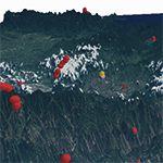
DEM Philippines Field localities 3D Digital Elevation Model of the Philippine islands including collection localities from Larry Heaney. Imagery is from LandSat 8 ETM+
What species are where in the world?
Who was where throughout our own cultural past?
Locality data can be trickier to handle than you might expect.
We're under construction right now, but come back soon to see some visualizations of places where collections have been and researchers have trekked.
[In the meantime, peruse some maps!]